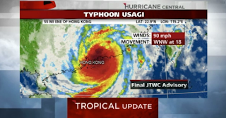
Typhoon Usagi, a strong tropical cyclone in the western Pacific Ocean, has made landfall in China's Guangdong Province in the city of Shanwei, about 90 miles east-northeast of Kowloon, Hong Kong. The typhoon is weakening over land, with winds now equivalent to a Category 1 hurricane. Based on Chinese radar imagery, landfall appeared to occur Sunday evening between 7 p.m. and 8 p.m. Hong Kong time (7 a.m. and 8 a.m. EDT U.S. time).
According to the Joint Typhoon Warning Center, as of 11 p.m. Hong Kong time Sunday (11 a.m. EDT Sunday U.S. time), Usagi was centered near Huizhou City, Guangdong, or 60 miles northeast of Kowloon, Hong Kong. It is moving toward the west-northwest at 18 miles per hour. Maximum sustained winds are estimated at 90 mph.
Usagi Forecast Path
Usagi will continue to track toward the west to west-northwest. This track is taking the center of Usagi just north of Hong Kong overnight Sunday into Monday local time; that is when the center will make its closest approach to Hong Kong.
(WUNDERMAP: Tracking Usagi)
The storm has already dumped more than a foot of rain in parts of Taiwan and is blamed for the deaths of two people in The Philippines. Usagi will pack very strong winds and heavy rain, both of which present significant danger to those in the storm's path.
Latest IR Satellite Image
A tropical cyclone is dubbed a "super typhoon" when maximum sustained winds reach at least 150 mph. Usagi underwent a period of rapid intensification from early Wednesday through midday Thursday (U.S. Eastern time), going from a 55-knot (65-mph) tropical storm to a 140-knot (160-mph) super typhoon in just 33 hours, or just under a 100 mph intensification, based on satellite estimates of intensity.
By Friday night, though, Usagi underwent an eyewall replacement cycle, causing the storm to weaken slightly. In addition, the outer rain bands began to interact with Taiwan and Luzon, disrupting the storm's low-level inflow, further weakening the storm.
On Saturday, animated multi-spectral satellite imagery indicated a resurgence in the storm's eyewall development, but the typhoon was never able to regain its former power before making landfall.
Here are the impacts by location for Usagi:
Hong Kong
- Airlines Cathay Pacific and Dragonair announced Saturday they would halt all flights in and out of Hong Kong from 6 p.m. Sunday.
- Closest approach of center of Usagi: Now through Monday morning around 1 a.m. Hong Kong time (Sunday at 1 p.m. EDT in the U.S.)
- A sustained wind of 56 mph (90 km/h) and a wind gust of 76 mph (123 km/h) was reported at Cheung Chau, Hong Kong, at 9 p.m. Sunday local time.
- Winds are starting to subside in parts of Hong Kong and the barometric pressure is beginning to increase as the typhoon weakens and makes its closest geographic approach to Hong Kong.
- Impacts: Tropical storm force winds of 40 to 70 mph are occurring in some areas, along with hurricane-force gusts. Hong Kong's complex terrain and numerous skyscrapers are causing winds to be higher in some places and lower in others. Periods of heavy rain will occur as well.
- Northwesterly winds will become southwesterly Monday morning (local time) as the center of Usagi passes north and then northwest of Hong Kong.
- Tides are running 1 to 2 feet above normal levels.
- Local forecast: Hong Kong
Hong Kong is one of the most densely populated places in the world, with over 7.1 million residents, as of a 2012 estimate.
China
- Guangdong Province, where landfall occurred, is taking the brunt of Usagi's impact. The population of Guangdong is about 105 million, making it the third most populous province or state in the world (the top two are in India).
- A station pressure of 938.9 millibars, or about 940 millibars at sea level, was measured near the point of landfall in the city of Shanwei at 8 p.m. Hong Kong time Sunday. Shanwei is a coastal city of over 2 million people.
- The center of Usagi will move west or west-northwest through the major cities of the Pearl River Delta, such as Shenzhen and Guangzhou, with winds possibly gusting to hurricane force along with heavy rainfall.
- China's government weather agency is forecasting 4 to 10 inches of rainfall across much of Guangdong Province along the path of Usagi.
- Significant storm surge has been reported around the city of Shantou, east of where Usagi made landfall, due to the large area of onshore winds on the right side of Usagi's circulation.
- Local forecast: Guangzhou
Earlier in Usagi's path:
Taiwan
- The center of Usagi passed south of the southern tip of Taiwan.
- Impacts: Surge flooding/battering waves (eastern coast especially) and flooding rain/mudslides (central, eastern Taiwan).
- More than a foot of rain fell in some locations as Usagi passed by.
- Local forecast: Taipei
Northern Philippines
- The center of Usagi passed north of the north coast of Luzon on Saturday, local time.
- The Batanes Islands, in the extreme northern Philippines north of Luzon, took a direct hit. Basco Airport reported a sustained wind of 112 mph, then went nearly calm as the eye passed overhead and the pressure dropped to 930 millibars.
- Local forecast: Manila


No comments:
Post a Comment